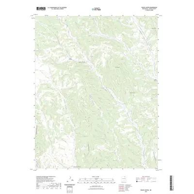
2023 Map of House Canyon
USGS Topo · Published 2023About this map
Cerrososo Creek snakes through a complex network of drainages in this modern survey of Colfax County, New Mexico. The landscape is defined by its deep canyons, including the namesake House Canyon and the prominent Van Bremmer Canyon, which serve as natural corridors through the high country. Human passage is marked by a handful of mountain roads like Van Bremmer Rd and FR 1950, which follow the contours of the land. The presence of family-named features like Valdez Canyon and Juan Brailla Canyon points to a history of land use and settlement tied to these specific watercourses. To the south and west, the terrain transitions toward Chase Canyon and Cottonwood Canyon, illustrating the interconnected nature of the Ponil Creek watershed and the rugged interior of the Sangre de Cristo foothills.
Find a feature on this map
20 named features on this map. Tap any name to fly to it.
Don’t see what you’re looking for? This feature index may not catch every label — zoom into the map to look around manually.
Map Details
Editions of this 2023 House Canyon Map
This is the sole edition of this map. No revisions or reprints were ever made.
Other maps of this area

1954 · Raton
USGS Topo · 1:250,000

1955 · Cimarron
USGS Topo · 1:62,500

1955 · Ute Park
USGS Topo · 1:62,500

1958 · Raton
USGS Topo · 1:250,000

1962 · Ash Mountain
USGS Topo · 1:62,500

1962 · Casa Grande
USGS Topo · 1:62,500

1981 · Raton
USGS Topo · 1:100,000

1982 · Wheeler Peak
USGS Topo · 1:100,000
1986 · Van Bremmer Park
USGS Topo · 1:24,000
1986 · Caliente Canyon South
USGS Topo · 1:24,000