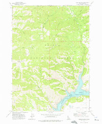
1973 Map of House Mountain
USGS Topo · Published 1976About this map
Anderson Ranch Reservoir defines the southern reach of this landscape, where the South Fork Boise River was impounded to create a massive high-country basin. The terrain is marked by significant elevation changes, rising from the water's edge toward the peaks of House Mountain and Granite Mountain within the Boise National Forest. The 1970s survey captures a wilderness infrastructure of trails and jeep trails connecting remote water sources like Daveys Spring and Ice Springs. Mapping by the U.S. Bureau of Reclamation provides detailed underwater contours for the reservoir, reflecting its mid-century development. While much of the area remains undeveloped forest, the margins of the Camas Prairie and Wilson Flat show the transition from steep mountain slopes to the more level plateaus that historically supported local grazing and transit. Smaller drainages, including Evans Creek and Myrtle Creek, illustrate the complex watershed feeding into the reservoir system.
Find a feature on this map
40 named features on this map. Tap any name to fly to it.
Don’t see what you’re looking for? This feature index may not catch every label — zoom into the map to look around manually.
Map Details
Editions of this 1973 House Mountain Map
This is the sole edition of this map. No revisions or reprints were ever made.
Other maps of this area

1892 · Mountain Home
USGS Topo · 1:125,000

1892 · Camas Prairie
USGS Topo · 1:125,000

1893 · Mountain Home
USGS Topo · 1:125,000

1893 · Camas Prairie
USGS Topo · 1:125,000

1894 · Idaho Basin
USGS Topo · 1:125,000

1894 · Rocky Bar
USGS Topo · 1:125,000

1955 · Hailey
USGS Topo · 1:250,000

1959 · Hailey
USGS Topo · 1:250,000

1960 · Danskin Peak
USGS Topo · 1:62,500

1962 · Hailey
USGS Topo · 1:250,000