
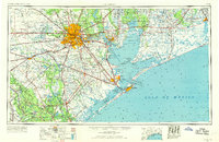
1956 Map of Houston
USGS Topo · Published 1963This historical map portrays the area of Houston in 1956, primarily covering Harris County as well as portions of Chambers County, Fort Bend County, Wharton County, Brazoria County, Galveston County, Matagorda County, Jefferson County, Liberty County, and Waller County. Featuring a scale of 1:250000, this map provides a highly detailed snapshot of the terrain, roads, buildings, counties, and historical landmarks in the Houston region at the time. Published in 1963, it is one of 2 known editions of this map due to revisions or reprints.
Find a feature on this map
286 named features on this map. Tap any name to fly to it.
Don’t see what you’re looking for? This feature index may not catch every label — zoom into the map to look around manually.
Map Details
Editions of this 1956 Houston Map
2 editions found
Historical Maps of Townewest Through Time
4 maps found


