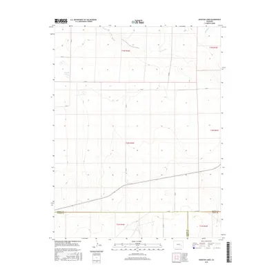
2016 Map of Houston Lakes
USGS Topo · Published 2016About this map
Houston Lakes sits at the heart of this high-plains landscape where the boundaries of Otero, Kiowa, and Bent Counties converge. The terrain is defined by the ephemeral drainage of Sand Arroyo and the eastward flow of Mustang Cr, cutting through a grid of section lines and range townships. This area represents the open ranching country of southeastern Colorado in the mid-2010s, where land use is marked by long-standing agricultural holdings like the Lewis Ranch and McIntosh Ranch.
Find a feature on this map
22 named features on this map. Tap any name to fly to it.
Don’t see what you’re looking for? This feature index may not catch every label — zoom into the map to look around manually.
Map Details
Editions of this 2016 Houston Lakes Map
This is the sole edition of this map. No revisions or reprints were ever made.
Other maps of this area

1891 · Catlin
USGS Topo · 1:125,000

1891 · Las Animas
USGS Topo · 1:125,000

1893 · Las Animas
USGS Topo · 1:125,000

1893 · Catlin
USGS Topo · 1:125,000

1954 · Meredith Hill
USGS Topo · 1:24,000

1954 · Lamar
USGS Topo · 1:250,000

1955 · Mc Intosh Ranch
USGS Topo · 1:24,000
1955 · Lewis Ranch
USGS Topo · 1:24,000

1958 · Lamar
USGS Topo · 1:250,000

1974 · Arlington NE
USGS Topo · 1:24,000