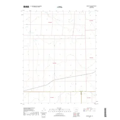
2019 Map of Houston Lakes
USGS Topo · Published 2019About this map
Houston Lakes sits at the heart of this high plains landscape, where the convergence of Kiowa, Otero, and Bent counties reveals a rural infrastructure built around seasonal water and section-line travel. The drainage of Sand Arroyo meanders through the northern sections, carving subtle relief into the terrain as it trends toward the northeast. This 2019 survey documents a network of county roads, including Co Rd H and Co Rd F, that define the modern boundaries of large land tracts. The presence of Mustang Cr in the far corner further emphasizes the importance of these watercourses in an otherwise arid environment, providing essential points of reference for land management and local history.
Find a feature on this map
18 named features on this map. Tap any name to fly to it.
Don’t see what you’re looking for? This feature index may not catch every label — zoom into the map to look around manually.
Map Details
Editions of this 2019 Houston Lakes Map
This is the sole edition of this map. No revisions or reprints were ever made.
Other maps of this area

1891 · Catlin
USGS Topo · 1:125,000

1891 · Las Animas
USGS Topo · 1:125,000

1893 · Las Animas
USGS Topo · 1:125,000

1893 · Catlin
USGS Topo · 1:125,000

1954 · Meredith Hill
USGS Topo · 1:24,000

1954 · Lamar
USGS Topo · 1:250,000

1955 · Mc Intosh Ranch
USGS Topo · 1:24,000
1955 · Lewis Ranch
USGS Topo · 1:24,000

1958 · Lamar
USGS Topo · 1:250,000

1974 · Arlington NE
USGS Topo · 1:24,000