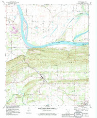
1990 Map of Houston
USGS Topo · Published 1995About this map
Houston and Oppelo anchor this 1990s revision, which highlights the transition from the wide agricultural bottomlands of the Arkansas River to the upland ridges of Perry Mountain. The landscape is defined by its watercourses, including the Fourche La Fave River in the south and the Morrilton Cutoff to the north. Extensive alluvial plains like Sandtown Bottoms and Portland Bottoms dominate the northern half, while the central portion is dominated by the steep elevations of Toms Mountain. Genealogists will find significant value in the documentation of local burial grounds, including Leach Cem, Bland Cem, May Cem, and the Houston Cem. The inclusion of the Harris Brake State WMA and numerous gravel pits and quarries indicates a region defined by both conservation and local extraction industry.
Find a feature on this map
33 named features on this map. Tap any name to fly to it.
Don’t see what you’re looking for? This feature index may not catch every label — zoom into the map to look around manually.
Map Details
Editions of this 1990 Houston Map
This is the sole edition of this map. No revisions or reprints were ever made.
Other maps of this area

1889 · Morrilton No. 3
USGS Topo · 1:62,500

1890 · Benton
USGS Topo · 1:125,000

1892 · Morrillton
USGS Topo · 1:125,000

1894 · Morrillton
USGS Topo · 1:125,000

1894 · Benton
USGS Topo · 1:125,000

1955 · Little Rock
USGS Topo · 1:250,000

1956 · Little Rock
USGS Topo · 1:250,000

1956 · Russellville
USGS Topo · 1:250,000

1960 · Little Rock
USGS Topo · 1:250,000

1961 · Menifee
USGS Topo · 1:24,000