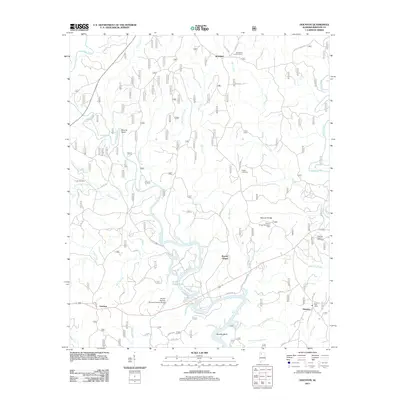
2011 Map of Houston
USGS Topo · Published 2011About this map
Lewis Smith Lake dominates the southern portion of this Alabama landscape, its intricate shoreline winding through the timbered valleys of Winston County. The Sipsey Fork feeds into the reservoir, passing through geographic landmarks like Moody Bend and Beasley Bend. This area shows a blend of public recreation and local heritage, with the Natural Bridge Recreation Area situated north of the lake.
Find a feature on this map
58 named features on this map. Tap any name to fly to it.
Don’t see what you’re looking for? This feature index may not catch every label — zoom into the map to look around manually.
Map Details
Editions of this 2011 Houston Map
This is the sole edition of this map. No revisions or reprints were ever made.
Other maps of this area

1935 · Upshaw
USGS Topo · 1:24,000

1935 · Danville
USGS Topo · 1:48,000

1936 · Moulton
USGS Topo · 1:48,000

1938 · Danville
USGS Topo · 1:62,500

1940 · Mt Hope
USGS Topo · 1:62,500

1956 · Gadsden
USGS Topo · 1:250,000

1958 · Gadsden
USGS Topo · 1:250,000

1960 · Gadsden
USGS Topo · 1:250,000
1960 · Bee Branch
USGS Topo · 1:24,000
1960 · Grayson
USGS Topo · 1:24,000