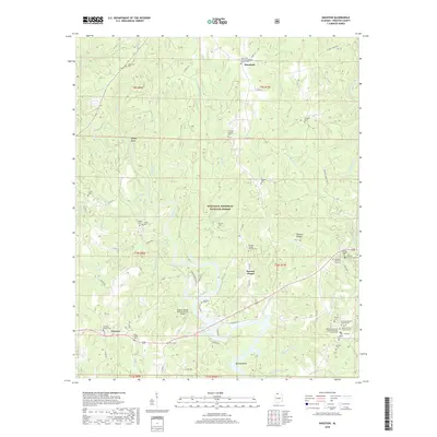
2018 Map of Houston
USGS Topo · Published 2018About this map
Lewis Smith Lake and the southern reaches of the William B. Bankhead National Forest dominate this landscape in eastern Winston County. The settlement of Houston serves as a focal point near the eastern edge, surrounded by a high density of small-town institutions including Houston Baptist Church, Houston Union Church, and several family-named burial grounds like Bailey Cem and Littles Cem. The terrain is deeply incised by the Sipsey Fork and its many tributaries, such as Grindstone Cr and Sandy Creek, creating a complex network of ridges and hollows that historically dictated local travel and settlement patterns.
Find a feature on this map
79 named features on this map. Tap any name to fly to it.
Don’t see what you’re looking for? This feature index may not catch every label — zoom into the map to look around manually.
Map Details
Editions of this 2018 Houston Map
This is the sole edition of this map. No revisions or reprints were ever made.
Other maps of this area

1935 · Upshaw
USGS Topo · 1:24,000

1935 · Danville
USGS Topo · 1:48,000

1936 · Moulton
USGS Topo · 1:48,000

1938 · Danville
USGS Topo · 1:62,500

1940 · Mt Hope
USGS Topo · 1:62,500

1956 · Gadsden
USGS Topo · 1:250,000

1958 · Gadsden
USGS Topo · 1:250,000

1960 · Gadsden
USGS Topo · 1:250,000
1960 · Bee Branch
USGS Topo · 1:24,000
1960 · Grayson
USGS Topo · 1:24,000