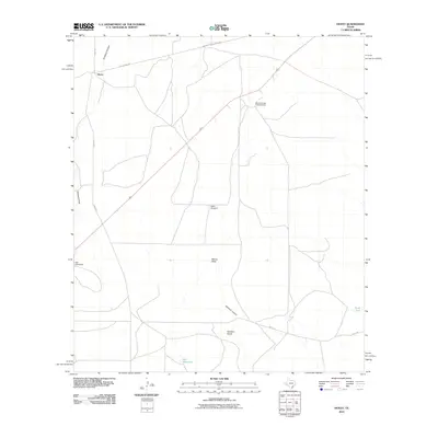
2010 Map of Hovey
USGS Topo · Published 2010About this map
Hovey and its surrounding ranchlands are depicted in this 2010 survey of Brewster County. The landscape is defined by its water management and geographic draws, essential for livestock in this arid region. Ranching infrastructure is prominent, with remote sites such as Burnt House Creek Ranch and various water sources including the Sulfur Windmill, Flat Windmills, and the Perch Tank. These features suggest a continuation of long-standing land use patterns where survival depends on the strategic placement of wells and tanks.
Find a feature on this map
14 named features on this map. Tap any name to fly to it.
Don’t see what you’re looking for? This feature index may not catch every label — zoom into the map to look around manually.
Map Details
Editions of this 2010 Hovey Map
This is the sole edition of this map. No revisions or reprints were ever made.
Other maps of this area

1923 · Hess Canyon
USGS Topo · 1:62,500

1923 · Altuda
USGS Topo · 1:62,500

1929 · Hovey
USGS Topo · 1:125,000

1954 · Fort Stockton
USGS Topo · 1:250,000

1958 · Fort Stockton
USGS Topo · 1:250,000

1973 · Fort Stockton
USGS Topo · 1:250,000
1980 · Chancellor
USGS Topo · 1:24,000

1980 · Cave Mesa
USGS Topo · 1:24,000

1980 · Hovey
USGS Topo · 1:24,000
1980 · Hovey SW
USGS Topo · 1:24,000