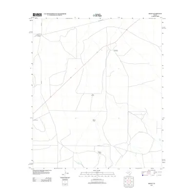
2012 Map of Hovey
USGS Topo · Published 2012About this map
Hovey serves as the focal point for this trans-Pecos landscape, situated at the junction of the Hovey Rd and the Old Alpine Hwy. The settlement and surrounding rangelands represent the ranching economy of West Texas in the early 21st century, where water management is the primary driver of human geography. Named water features like Sulfur Windmill, Flat Windmills, and Perch Tank are essential landmarks in this arid terrain. The map reveals a network of local tracks, including Mills Rd, which connect isolated homesteads like the Burnt House Creek Ranch to the broader region. Topographic features such as Moose Draw and the evocatively named Robbers Roost provide essential context for understanding the natural drainage and historical character of Brewster County.
Find a feature on this map
11 named features on this map. Tap any name to fly to it.
Don’t see what you’re looking for? This feature index may not catch every label — zoom into the map to look around manually.
Map Details
Editions of this 2012 Hovey Map
This is the sole edition of this map. No revisions or reprints were ever made.
Other maps of this area

1923 · Hess Canyon
USGS Topo · 1:62,500

1923 · Altuda
USGS Topo · 1:62,500

1929 · Hovey
USGS Topo · 1:125,000

1954 · Fort Stockton
USGS Topo · 1:250,000

1958 · Fort Stockton
USGS Topo · 1:250,000

1973 · Fort Stockton
USGS Topo · 1:250,000
1980 · Chancellor
USGS Topo · 1:24,000

1980 · Cave Mesa
USGS Topo · 1:24,000

1980 · Hovey
USGS Topo · 1:24,000
1980 · Hovey SW
USGS Topo · 1:24,000