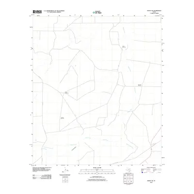
2010 Map of Hovey NE
USGS Topo · Published 2010About this map
Isolated windmills and seasonal drainage patterns define this arid West Texas landscape in the Trans-Pecos region. Crucial water sources for ranching operations are scattered across the terrain, including North Windmill, Big Draw Windmill, and Webb Windmill, which signify the pastoral economy of Pecos County. The topographical structure is shaped by the intermittent flows of Paisano Creek and Musquiz Creek, along with the prominent Antelope Draw and the descriptively named Burnt House Creek.
Find a feature on this map
10 named features on this map. Tap any name to fly to it.
Don’t see what you’re looking for? This feature index may not catch every label — zoom into the map to look around manually.
Map Details
Editions of this 2010 Hovey NE Map
This is the sole edition of this map. No revisions or reprints were ever made.
Other maps of this area

1929 · Hovey
USGS Topo · 1:125,000

1954 · Fort Stockton
USGS Topo · 1:250,000

1958 · Fort Stockton
USGS Topo · 1:250,000

1970 · Belding SW
USGS Topo · 1:24,000

1970 · Deep Well Ranch
USGS Topo · 1:24,000

1970 · Deep Well Ranch SE
USGS Topo · 1:24,000

1973 · Fort Stockton
USGS Topo · 1:250,000
1980 · Chancellor
USGS Topo · 1:24,000

1980 · Cave Mesa
USGS Topo · 1:24,000

1980 · Hovey
USGS Topo · 1:24,000