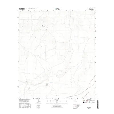
2016 Map of Hovey NE
USGS Topo · Published 2016About this map
Paisano Cr and a series of deep drainage draws define this segment of the Trans-Pecos landscape in the mid-2010s. The terrain is characterized by the confluence of Coyanosa Draw and Antelope Draw, showing the intricate hydrological patterns typical of West Texas. Transport across this arid expanse is facilitated by Hovey Rd in the west and the Old Alpine Hwy in the southeast, which skirts the edge of Burnt House Cr. The map captures the remote character of Pecos County, where naming is largely reserved for watercourses like Musquiz Cr and the Upper Coyanosa Draw. This survey provides a precise record of the topography and drainage before modern land use might further alter these seasonal waterways.
Find a feature on this map
8 named features on this map. Tap any name to fly to it.
Don’t see what you’re looking for? This feature index may not catch every label — zoom into the map to look around manually.
Map Details
Editions of this 2016 Hovey NE Map
This is the sole edition of this map. No revisions or reprints were ever made.
Other maps of this area

1929 · Hovey
USGS Topo · 1:125,000

1954 · Fort Stockton
USGS Topo · 1:250,000

1958 · Fort Stockton
USGS Topo · 1:250,000

1970 · Belding SW
USGS Topo · 1:24,000

1970 · Deep Well Ranch
USGS Topo · 1:24,000

1970 · Deep Well Ranch SE
USGS Topo · 1:24,000

1973 · Fort Stockton
USGS Topo · 1:250,000
1980 · Chancellor
USGS Topo · 1:24,000

1980 · Cave Mesa
USGS Topo · 1:24,000

1980 · Hovey
USGS Topo · 1:24,000