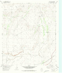
1980 Map of Hovey NE
USGS Topo · Published 1981About this map
The Atchison Topeka and Santa Fe railroad cuts across the southeast corner of this West Texas landscape, tracing a path through the arid Pecos County terrain. This area is defined by its intermittent drainage systems, notably the Coyanosa Draw and Burnt House Creek, which highlight the importance of water management in this high-plains environment. A network of windmills, including the Headquarters Windmill, Webb Windmill, and Hackney Windmill, suggests a landscape organized around ranching and livestock, where reliable water sources were critical for operations. Evidence of industrial activity is present through scattered Drill Hole locations and a Pipeline crossing the northern section. The terrain transitions from the low-lying Musquiz Creek and Antelope Draw up toward the more complex topography to the north, providing a clear record of the region's ranching infrastructure and mineral exploration in the late twentieth century.
Find a feature on this map
16 named features on this map. Tap any name to fly to it.
Don’t see what you’re looking for? This feature index may not catch every label — zoom into the map to look around manually.
Map Details
Editions of this 1980 Hovey NE Map
This is the sole edition of this map. No revisions or reprints were ever made.
Other maps of this area

1929 · Hovey
USGS Topo · 1:125,000

1954 · Fort Stockton
USGS Topo · 1:250,000

1958 · Fort Stockton
USGS Topo · 1:250,000

1970 · Belding SW
USGS Topo · 1:24,000

1970 · Deep Well Ranch
USGS Topo · 1:24,000

1970 · Deep Well Ranch SE
USGS Topo · 1:24,000

1973 · Fort Stockton
USGS Topo · 1:250,000
1980 · Chancellor
USGS Topo · 1:24,000

1980 · Cave Mesa
USGS Topo · 1:24,000

1980 · Hovey
USGS Topo · 1:24,000