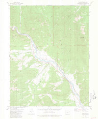
1981 Map of Howard
USGS Topo · Published 1981About this map
The Arkansas River corridor serves as the primary artery through this Colorado landscape, flanked by the Denver and Rio Grande Western RR and several prominent mountain peaks. The settlement of Howard is a focal point, featuring the Howard Sch, a Rodeo Ground, and the nearby Howard Cem. The map illustrates a complex drainage system where Badger Creek, Cherry Creek, and Stout Creek descend from the high ground into the river valley. To the south, the boundary of the San Isabel National Forest encompasses the Rainbow Trail, while the eastern portion is dominated by the heights of Burned Timber Mountain and Copper Mountain. Economic activity is evident through numerous prospects and an Old RR Grade, marking the historical transit and mining patterns of Fremont County before the 1980s.
Find a feature on this map
33 named features on this map. Tap any name to fly to it.
Don’t see what you’re looking for? This feature index may not catch every label — zoom into the map to look around manually.
Map Details
Editions of this 1981 Howard Map
3 editions found
Other maps of this area

1954 · Pueblo
USGS Topo · 1:250,000

1956 · Cameron Mountain
USGS Topo · 1:62,500

1957 · Pueblo
USGS Topo · 1:250,000

1958 · Pueblo
USGS Topo · 1:250,000

1959 · Black Mountain
USGS Topo · 1:62,500

1959 · Howard
USGS Topo · 1:62,500

1959 · Cotopaxi
USGS Topo · 1:62,500

1962 · Pueblo
USGS Topo · 1:250,000

1966 · Pueblo
USGS Topo · 1:250,000
1980 · Wellsville
USGS Topo · 1:24,000