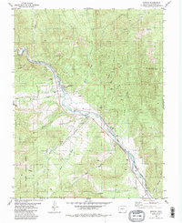
1981 Map of Howard
USGS Topo · Published 1985About this map
The Arkansas River corridor defines this portion of Fremont County, serving as the primary artery for both transportation and settlement in the early 1980s. The Denver and Rio Grande Western railroad tracks parallel the river's winding path, passing through the community of Howard and the small siding at Vallie. Local civic life is anchored by the Howard Co Sch, the Howard Cem, and the communal Rodeo Ground.
Find a feature on this map
35 named features on this map. Tap any name to fly to it.
Don’t see what you’re looking for? This feature index may not catch every label — zoom into the map to look around manually.
Map Details
Editions of this 1981 Howard Map
3 editions found
Other maps of this area

1954 · Pueblo
USGS Topo · 1:250,000

1956 · Cameron Mountain
USGS Topo · 1:62,500

1957 · Pueblo
USGS Topo · 1:250,000

1958 · Pueblo
USGS Topo · 1:250,000

1959 · Black Mountain
USGS Topo · 1:62,500

1959 · Howard
USGS Topo · 1:62,500

1959 · Cotopaxi
USGS Topo · 1:62,500

1962 · Pueblo
USGS Topo · 1:250,000

1966 · Pueblo
USGS Topo · 1:250,000
1980 · Wellsville
USGS Topo · 1:24,000