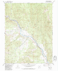
1981 Map of Howard
USGS Topo · Published 1985About this map
The Arkansas River serves as the central artery through this portion of Fremont County, carving a path that dictated the placement of early transportation and industry. The Denver and Rio Grande Western railroad tracks closely parallel the river's course, connecting the small settlements of Howard and Vallie. While the river valley supports concentrated development like the Howard Cem and various gravel pits, the surrounding terrain rises sharply into the high country. To the southwest, the San Isabel National Forest encompasses the drainage basins of Stout Creek and Cherry Creek, where the Rainbow Trail skirts the lower slopes. The presence of numerous labeled prospects and mines, such as those along Alkali Gulch and Sand Gulch, highlights a landscape defined by small-scale mineral exploration tucked between the riverside rails and the heights of Copper Mountain.
Find a feature on this map
29 named features on this map. Tap any name to fly to it.
Don’t see what you’re looking for? This feature index may not catch every label — zoom into the map to look around manually.
Map Details
Editions of this 1981 Howard Map
3 editions found
Other maps of this area

1954 · Pueblo
USGS Topo · 1:250,000

1956 · Cameron Mountain
USGS Topo · 1:62,500

1957 · Pueblo
USGS Topo · 1:250,000

1958 · Pueblo
USGS Topo · 1:250,000

1959 · Black Mountain
USGS Topo · 1:62,500

1959 · Howard
USGS Topo · 1:62,500

1959 · Cotopaxi
USGS Topo · 1:62,500

1962 · Pueblo
USGS Topo · 1:250,000

1966 · Pueblo
USGS Topo · 1:250,000
1980 · Wellsville
USGS Topo · 1:24,000