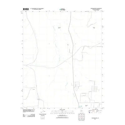
2011 Map of Howard Mesa
USGS Topo · Published 2011About this map
Red Lake Valley and the surrounding high-desert plateau of Coconino County are defined by seasonal watercourses and evolving residential patterns in this 2011 record. The drainage of Red Lake Wash cuts a significant path through the center of the map, terminating near Red Lake in the south. The presence of Bly Siding along the northern corridor hints at the region's transportation history, while modern subdivisions are evidenced by street names like N Stagecoach Dr and N Pony Express Dr. These names, alongside Espee Rd, evoke the ranching and rail heritage of northern Arizona. The landscape transitions from the flat expanses of LO Flat and LO Draw to the more prominent elevations of Howard Mesa and the depths of Horse Trap Canyon, reflecting the varied topography east of the Grand Canyon region.
Find a feature on this map
27 named features on this map. Tap any name to fly to it.
Don’t see what you’re looking for? This feature index may not catch every label — zoom into the map to look around manually.
Map Details
Editions of this 2011 Howard Mesa Map
This is the sole edition of this map. No revisions or reprints were ever made.
Other maps of this area

1886 · Chino
USGS Topo · 1:250,000

1891 · Chino
USGS Topo · 1:250,000

1922 · Williams
USGS Topo · 1:125,000

1948 · Williams
USGS Topo · 1:250,000

1954 · Williams
USGS Topo · 1:250,000

1956 · Williams
USGS Topo · 1:250,000

1960 · Williams
USGS Topo · 1:250,000
1960 · Williams
USGS Topo · 1:62,500

1961 · Williams
USGS Topo · 1:250,000

1962 · Valle
USGS Topo · 1:62,500