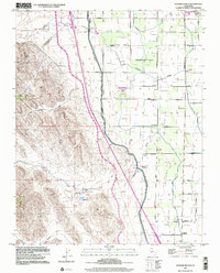
1999 Map of Howard Ranch
USGS Topo · Published 2002About this map
The California Aqueduct and Delta - Mendota Canal cut a precise north-south path through this landscape, marking the intense engineering required to move water through the San Joaquin Valley. At the foot of the hills, Howard Ranch and a nearby Reservoir sit at the mouth of Quinto Creek, where the transition from the steep terrain of Whitney Canyon meets the organized agricultural grid of the valley floor. The map captures a high-resolution view of the rural infrastructure near Gustine at the turn of the millennium, documenting a network of family-named roads like Jorgensen Road and Pfitzer Road. This specific edition reveals the persistent rural character of western Merced County, where small landmarks like the Cottonwood School and Romero School remained as focal points for the surrounding ranchlands and orchards long after many such rural districts consolidated elsewhere.
Find a feature on this map
42 named features on this map. Tap any name to fly to it.
Don’t see what you’re looking for? This feature index may not catch every label — zoom into the map to look around manually.
Map Details
Editions of this 1999 Howard Ranch Map
This is the sole edition of this map. No revisions or reprints were ever made.
Other maps of this area

1917 · Newman
USGS Topo · 1:31,680

1918 · Gustine
USGS Topo · 1:31,680

1919 · Orestimba
USGS Topo · 1:62,500

1919 · Orestimba Creek
USGS Topo · 1:31,680

1919 · Ingomar
USGS Topo · 1:31,680

1920 · Pacheco Pass
USGS Topo · 1:62,500

1921 · Volta
USGS Topo · 1:31,680

1922 · San Luis Creek
USGS Topo · 1:31,680

1922 · Howard Ranch
USGS Topo · 1:31,680

1940 · Pacheco Pass
USGS Topo · 1:62,500