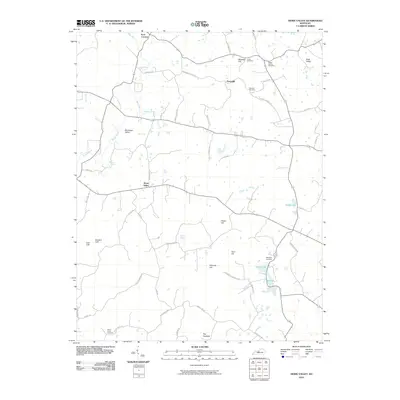
2010 Map of Howe Valley
USGS Topo · Published 2010About this map
Howe Valley serves as a central hub for this rural Kentucky landscape, where the meandering course of the Rough River defines the western terrain. The area is characterized by a series of distinct topographic features, from the elevations of Blueball Hill and Wilmoth Hill to the karst-influenced drainage indicated by Roaring Spring and Stiles Spring. Genealogists will find significant value in the distribution of family and community burial grounds, including Ridge Spring Cemetery near Nalls Valley and Wheatley Cemetery closer to Greer Lake. Settlement patterns follow an established network of named roads like Blueball Church Rd and W Yates Chapel Rd, connecting the hamlets of Perryville and Four Corners. The map also documents specific local landmarks such as The Hogback and Buzzard Cliff, providing a detailed look at the rural Hardin County interior at the start of the 21st century.
Find a feature on this map
56 named features on this map. Tap any name to fly to it.
Don’t see what you’re looking for? This feature index may not catch every label — zoom into the map to look around manually.
Map Details
Editions of this 2010 Howe Valley Map
This is the sole edition of this map. No revisions or reprints were ever made.
Other maps of this area

1932 · Big Clifty
USGS Topo · 1:62,500

1935 · Elizabethtown
USGS Topo · 1:48,000

1936 · Vine Grove
USGS Topo · 1:62,500

1938 · Elizabethtown
USGS Topo · 1:62,500

1941 · Ekron
USGS Topo · 1:62,500

1943 · Vine Grove
USGS Topo · 1:62,500

1946 · Vine Grove
USGS Topo · 1:24,000

1946 · Vine Grove
USGS Topo · 1:62,500

1947 · Ekron
USGS Topo · 1:62,500
1948 · Flaherty
USGS Topo · 1:24,000