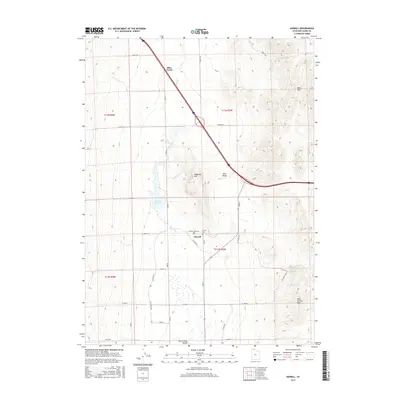
2017 Map of Howell
USGS Topo · Published 2017About this map
Howell occupies a central position in the Blue Creek Valley, surrounded by the high terrain of the West Hills and the Blue Spring Hills. This 2017 survey shows a landscape defined by water management and agricultural infrastructure, where Blue Cr Reservoir and various springs like Blue Creek Spring and Wheatley Spring provide essential resources in an otherwise arid basin. The town center is marked by a Po and the Howell Cem, while a network of named roads such as E Canal Rd and W Canal St suggests a long-standing reliance on irrigation and local transport. To the north, the Indian Trl cuts across the slopes of the hills, hinting at older routes through this portion of Box Elder County. The topography is varied, featuring prominent landmarks such as Anderson Hill and the Blue Ridge, which separate the valley floor from the higher peaks to the east.
Find a feature on this map
37 named features on this map. Tap any name to fly to it.
Don’t see what you’re looking for? This feature index may not catch every label — zoom into the map to look around manually.
Map Details
Editions of this 2017 Howell Map
This is the sole edition of this map. No revisions or reprints were ever made.
Other maps of this area

1954 · Brigham City
USGS Topo · 1:250,000

1958 · Brigham City
USGS Topo · 1:250,000

1961 · Thatcher Mountain
USGS Topo · 1:62,500

1962 · Brigham City
USGS Topo · 1:250,000

1968 · Sunset Pass
USGS Topo · 1:24,000
1968 · Limekiln Knoll
USGS Topo · 1:24,000

1968 · Howell
USGS Topo · 1:24,000

1968 · Ridgedale Pass
USGS Topo · 1:24,000
1968 · Blind Springs
USGS Topo · 1:24,000

1968 · Rattlesnake Pass
USGS Topo · 1:24,000