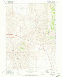
1968 Map of Blind Springs
USGS Topo · Published 1972About this map
Whites Valley and the West Hills dominate this high-desert landscape in northern Utah as it was surveyed in the late 1960s. The terrain is defined by a series of deep drainages, including Teponce Canyon, Chokecherry Canyon, and Blind Springs Canyon, which cut through the ridges toward the valley floor. The map records the intersection of natural landmarks and early transport routes, featuring the Indian Trail in the north and various Jeep Trails navigating the elevation changes of the Blue Springs Hills. Human activity is concentrated near the settlement of Bothwell and the namesake Blind Springs, with several Gravel Pits and a solitary Well indicating the area's resource extraction and water management during this era of rural development.
Find a feature on this map
20 named features on this map. Tap any name to fly to it.
Don’t see what you’re looking for? This feature index may not catch every label — zoom into the map to look around manually.
Map Details
Editions of this 1968 Blind Springs Map
This is the sole edition of this map. No revisions or reprints were ever made.
Other maps of this area

1954 · Brigham City
USGS Topo · 1:250,000

1958 · Brigham City
USGS Topo · 1:250,000

1961 · Thatcher Mountain
USGS Topo · 1:62,500

1961 · Tremonton
USGS Topo · 1:24,000

1962 · Brigham City
USGS Topo · 1:250,000
1964 · Riverside
USGS Topo · 1:24,000
1964 · Portage
USGS Topo · 1:24,000
1968 · Limekiln Knoll
USGS Topo · 1:24,000

1968 · Howell
USGS Topo · 1:24,000

1968 · Ridgedale Pass
USGS Topo · 1:24,000