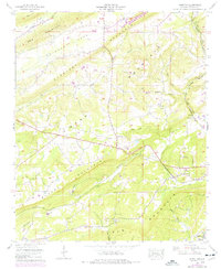
1959 Map of Howelton
USGS Topo · Published 1976About this map
Sand Mountain and Straight Mountain define the topography of this Etowah County landscape, creating the distinct lowland of Bristow Cove and Greasy Cove. In the late 1950s, the rural community of Howelton served as a central point for the surrounding farmsteads and family-named cemeteries, including Howelton Cem and Dillard Cem. The Louisville and Nashville railroad cuts through the southern terrain, passing near Ivalee and the Ivalee School, while an Old Line of the same railroad is visible further north. The map documents numerous rural congregations like Morton Chapel and New Welcome Church, alongside natural features like Brasher Spring and the winding course of Bristow Creek. This survey provides a look at the settlement patterns of the Alabama ridge-and-valley country before significant modernization changed these historic mountain corridors.
Find a feature on this map
52 named features on this map. Tap any name to fly to it.
Don’t see what you’re looking for? This feature index may not catch every label — zoom into the map to look around manually.
Map Details
Editions of this 1959 Howelton Map
2 editions found
Other maps of this area

1885 · Gadsden
USGS Topo · 1:125,000

1888 · Gadsden
USGS Topo · 1:125,000

1889 · Springville
USGS Topo · 1:125,000

1892 · Springville
USGS Topo · 1:125,000

1892 · Gadsden
USGS Topo · 1:125,000

1895 · Gadsden
USGS Topo · 1:125,000

1903 · Gadsden
USGS Topo · 1:125,000

1936 · Mountainboro
USGS Topo · 1:24,000

1936 · Rodentown
USGS Topo · 1:24,000

1936 · High Point
USGS Topo · 1:24,000