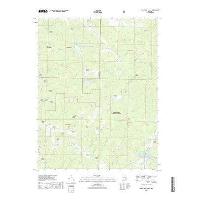
2017 Map of Howes Mill Spring
USGS Topo · Published 2017About this map
Howes Mill Spring and the surrounding drainages of the Mark Twain National Forest define this corner of the Ozark Highlands on the boundary of Dent and Crawford counties. This landscape is a complex network of hollows, including Deerpen Hollow, Rollins Bluff Hollow, and Onion Hollow, which feed into larger watercourses like the E Prong Crooked Cr and Water Fork Cr. The map preserves the locations of several family and community burial sites, such as Hutson-Walker Cem and Mounce Cem, which are vital for genealogical research in this rural area. Human presence is also marked by recreational landmarks like Tiefenthalers Lake Retreat and the Indian Trail State Forest Lake. The dense naming of small landforms, from Post Oak Flats to Gibson Hollow, reflects a deeply localized geography where every ridge and draw was known to the resident families who navigated these forest roads.
Find a feature on this map
77 named features on this map. Tap any name to fly to it.
Don’t see what you’re looking for? This feature index may not catch every label — zoom into the map to look around manually.
Map Details
Editions of this 2017 Howes Mill Spring Map
This is the sole edition of this map. No revisions or reprints were ever made.
Other maps of this area

1932 · Steelville
USGS Topo · 1:48,000

1933 · Steelville
USGS Topo · 1:62,500

1937 · Steelville
USGS Topo · 1:62,500

1941 · Stone Hill
USGS Topo · 1:62,500

1943 · Berryman
USGS Topo · 1:62,500

1943 · Boss
USGS Topo · 1:62,500

1945 · Stone Hill
USGS Topo · 1:62,500

1945 · Berryman
USGS Topo · 1:62,500

1946 · Boss
USGS Topo · 1:62,500

1949 · Rolla
USGS Topo · 1:250,000