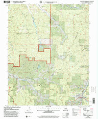
1999 Map of Howes Mill Spring
USGS Topo · Published 2002About this map
Howes Mill Spring emerges in this corner of the Ozark Highlands, where the land is defined by a dense network of named hollows and spring-fed waterways. Within the Mark Twain National Forest and Indian Trail Conservation Area, the terrain is etched by deep drainages like Plugtown Hollow and Plank Hollow. Local genealogy is well-represented through numerous family-named burial grounds, including Hutson-Walker Cem, Bowers Cem, and Hughes Cem. A notable shift in local industry is visible near the south border, where the Fish Hatcheries (Abandoned) sit along the banks of a creek, indicating a transition in the management of these limestone-filtered waters. The map captures the meeting of Dent and Crawford Counties amidst a landscape of isolated springs like Rattlesnake Spring and Wishing Spring.
Find a feature on this map
58 named features on this map. Tap any name to fly to it.
Don’t see what you’re looking for? This feature index may not catch every label — zoom into the map to look around manually.
Map Details
Editions of this 1999 Howes Mill Spring Map
This is the sole edition of this map. No revisions or reprints were ever made.
Other maps of this area

1932 · Steelville
USGS Topo · 1:48,000

1933 · Steelville
USGS Topo · 1:62,500

1937 · Steelville
USGS Topo · 1:62,500

1941 · Stone Hill
USGS Topo · 1:62,500

1943 · Berryman
USGS Topo · 1:62,500

1943 · Boss
USGS Topo · 1:62,500

1945 · Stone Hill
USGS Topo · 1:62,500

1945 · Berryman
USGS Topo · 1:62,500

1946 · Boss
USGS Topo · 1:62,500

1949 · Rolla
USGS Topo · 1:250,000