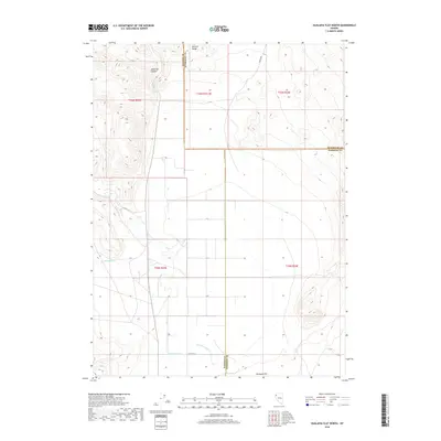
2018 Map of Hualapai Flat North
USGS Topo · Published 2018About this map
Hualapai Flat dominates the lower portion of this Nevada landscape, where the high desert floor meets the rising elevations of the Division Range to the north. This region is a study in desert hydrology and jurisdictional boundaries, as it marks the intersection of Washoe, Humboldt, and Pershing counties. Watercourses such as Red Mountain Cr and Cottonwood Cr flow toward the flat, while Negro Cr drains the northern reaches near the county lines. In the northwest, the deep incisions of Leadville Canyon provide a sharp contrast to the open valley floor below. Local access is defined by a sparse network of routes including C R 34, Barley Rd, and Jackson Ln, which serve the remote ranching and grazing lands established across these township and range sections.
Find a feature on this map
17 named features on this map. Tap any name to fly to it.
Don’t see what you’re looking for? This feature index may not catch every label — zoom into the map to look around manually.
Map Details
Editions of this 2018 Hualapai Flat North Map
This is the sole edition of this map. No revisions or reprints were ever made.
Other maps of this area

1886 · Granite Range
USGS Topo · 1:250,000

1889 · Long Valley
USGS Topo · 1:250,000

1894 · Granite Range
USGS Topo · 1:250,000

1954 · Vya
USGS Topo · 1:250,000

1955 · Lovelock
USGS Topo · 1:250,000

1958 · Vya
USGS Topo · 1:250,000

1959 · Lovelock
USGS Topo · 1:250,000

1962 · Vya
USGS Topo · 1:250,000

1980 · Melody Mountain
USGS Topo · 1:24,000
1980 · Leadville
USGS Topo · 1:24,000