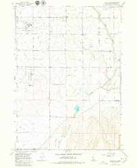
1979 Map of Hub Butte
USGS Topo · Published 1980About this map
Agricultural development and infrastructure define the landscape south of the Snake River canyon during the late 1970s. The region is marked by an extensive grid of section-line roads, such as 3400 North Road, and a sophisticated irrigation network including the Low Line Canal and High Line Canal. These waterways transform the high desert into productive farmland, with smaller channels like Lateral No 17 branching off to serve individual plots.
Find a feature on this map
33 named features on this map. Tap any name to fly to it.
Don’t see what you’re looking for? This feature index may not catch every label — zoom into the map to look around manually.
Map Details
Editions of this 1979 Hub Butte Map
This is the sole edition of this map. No revisions or reprints were ever made.
Other maps of this area

1950 · Filer
USGS Topo · 1:24,000

1950 · Jerome
USGS Topo · 1:62,500

1955 · Twin Falls
USGS Topo · 1:250,000

1958 · Twin Falls
USGS Topo · 1:250,000

1964 · Kimberly
USGS Topo · 1:24,000

1964 · Twin Falls
USGS Topo · 1:24,000

1965 · Hollister
USGS Topo · 1:24,000

1965 · Stricker Butte
USGS Topo · 1:24,000

1965 · Berger
USGS Topo · 1:24,000

1965 · Grand View Peak
USGS Topo · 1:24,000