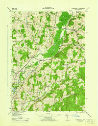
1944 Map of Hubbardsville
USGS Topo · Published 1944About this map
Agricultural crossroads and family-named corners define this section of Madison and Oneida counties during the mid-1940s. The village of Hubbardsville sits as a central hub, served by the Delaware Lackawanna and Western RR which follows the valley of the Sangerfield River. The landscape is notably dotted with numerous small hamlets and intersections like Sigby Corners, Durfee Corners, and Excell Corners, reflecting a dense pattern of rural settlement and local industry typical of Central New York before the consolidation of family farms. Education and community life were decentralized, evidenced by local landmarks such as the Union Sch and Beaver Meadow Sch. Topographical features like Turkey Hill and Cole Hill rise above the drainage basins of the Nine Mile River and Swamp River, illustrating the glacial drumlin and valley formations that dictate the region's transport routes and field placements.
Find a feature on this map
53 named features on this map. Tap any name to fly to it.
Don’t see what you’re looking for? This feature index may not catch every label — zoom into the map to look around manually.
Map Details
Editions of this 1944 Hubbardsville Map
This is the sole edition of this map. No revisions or reprints were ever made.
Other maps of this area

1902 · Morrisville
USGS Topo · 1:62,500

1903 · Norwich
USGS Topo · 1:62,500

1907 · Sangerfield
USGS Topo · 1:62,500

1910 · New Berlin
USGS Topo · 1:62,500

1912 · New Berlin
USGS Topo · 1:62,500

1943 · New Berlin North
USGS Topo · 1:24,000

1943 · Hubbardsville
USGS Topo · 1:24,000

1943 · Cassville
USGS Topo · 1:24,000

1943 · Sangerfield
USGS Topo · 1:62,500
1943 · Brookfield
USGS Topo · 1:24,000