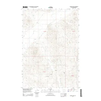
2014 Map of Huckins School
USGS Topo · Published 2014About this map
Huckins School stands as a focal point in this remote corner of Powder River County, where the sprawling Montana landscape is defined by the winding course of the Powder River. This map reveals a complex network of ephemeral drainages and canyons that have shaped the local ranching and settlement patterns for generations. To the south, Ellis Canyon and Kelly Draw cut through the terrain, leading toward the Eureka Reservoir. The geographic importance of water is evident in the naming of numerous tributaries like Buttermilk Cr, Bay Horse Cr, and Lone Tree Cr. Local transport relies on Bay Horse Rd and MT-391, which navigate the rises and falls between the Powder River valley and the high breaks of the surrounding township boundaries.
Find a feature on this map
24 named features on this map. Tap any name to fly to it.
Don’t see what you’re looking for? This feature index may not catch every label — zoom into the map to look around manually.
Map Details
Editions of this 2014 Huckins School Map
This is the sole edition of this map. No revisions or reprints were ever made.
Other maps of this area

1954 · Ekalaka
USGS Topo · 1:250,000

1956 · Ekalaka
USGS Topo · 1:250,000

1958 · Ekalaka
USGS Topo · 1:250,000

1965 · Ekalaka
USGS Topo · 1:250,000

1966 · Hodsdon Flats
USGS Topo · 1:24,000

1970 · Moorhead
USGS Topo · 1:24,000

1970 · Baldy Peak
USGS Topo · 1:24,000

1970 · Bloom Creek
USGS Topo · 1:24,000

1970 · Huckins School
USGS Topo · 1:24,000
1970 · Bay Horse
USGS Topo · 1:24,000