
1970 Map of Bloom Creek
USGS Topo · Published 1973About this map
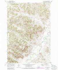
Custer National Forest lands dominate this corner of Powder River County, where a complex network of ephemeral drainages and small-scale water management projects define the ranching landscape. The survey captures the intricate cattle-country geography of the early 1970s, marked by numerous small impoundments such as Rimrock Reservoir, Bull Reservoir, Dunning Reservoir, and Swope Reservoir. These man-made features, alongside named water sources like Wolf Den Spring, illustrate the essential infrastructure required for livestock operations in the arid Montana breaks.
Find a feature on this map
18 named features on this map. Tap any name to fly to it.
Don’t see what you’re looking for? This feature index may not catch every label — zoom into the map to look around manually.
Map Details
Editions of this 1970 Bloom Creek Map
2 editions found
Other maps of this area

1954 · Ekalaka
USGS Topo · 1:250,000

1956 · Ekalaka
USGS Topo · 1:250,000

1958 · Ekalaka
USGS Topo · 1:250,000

1965 · Ekalaka
USGS Topo · 1:250,000

1966 · Phillips Butte
USGS Topo · 1:24,000

1966 · Hodsdon Flats
USGS Topo · 1:24,000

1970 · Moorhead
USGS Topo · 1:24,000

1970 · Huckins School
USGS Topo · 1:24,000
1970 · Sayle
USGS Topo · 1:24,000
1970 · Bradshaw Creek
USGS Topo · 1:24,000