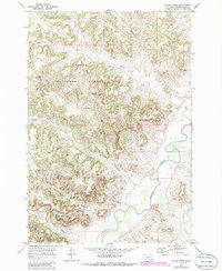
1970 Map of Bloom Creek
USGS Topo · Published 1986About this map
Custer National Forest dominates the landscape of Powder River County in this 1970 survey, revealing a remote region defined by complex drainage systems and isolated water management. The terrain is marked by the meandering course of the Powder River in the southeast, while the interior is etched with numerous named canyons and gullies including Dutch Gulch and Plum Creek.
Find a feature on this map
17 named features on this map. Tap any name to fly to it.
Don’t see what you’re looking for? This feature index may not catch every label — zoom into the map to look around manually.
Map Details
Editions of this 1970 Bloom Creek Map
2 editions found
Other maps of this area

1954 · Ekalaka
USGS Topo · 1:250,000

1956 · Ekalaka
USGS Topo · 1:250,000

1958 · Ekalaka
USGS Topo · 1:250,000

1965 · Ekalaka
USGS Topo · 1:250,000

1966 · Phillips Butte
USGS Topo · 1:24,000

1966 · Hodsdon Flats
USGS Topo · 1:24,000

1970 · Moorhead
USGS Topo · 1:24,000

1970 · Bloom Creek
USGS Topo · 1:24,000

1970 · Huckins School
USGS Topo · 1:24,000
1970 · Sayle
USGS Topo · 1:24,000