
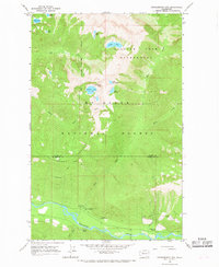
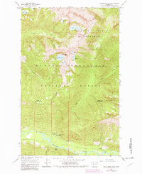
1966 Map of Huckleberry Mtn
USGS Topo · Published 1982About this map
The Suiattle River valley serves as the focal point for this 1960s study of the high country along the Skagit and Snohomish county line. The landscape is defined by the transition from the Mt Baker Snoqualmie National Forest into the protected Glacier Peak Wilderness Area, a region marked by high-altitude features like Hurricane Peak and Crater Lake. Human activity at this time concentrated along the river corridor, where the Suiattle Guard Station and Buck Creek Campground supported forest management and recreation.
Find a feature on this map
37 named features on this map. Tap any name to fly to it.
Don’t see what you’re looking for? This feature index may not catch every label — zoom into the map to look around manually.
Map Details
Editions of this 1966 Huckleberry Mtn Map
3 editions found
Historical Maps of Snohomish County Through Time
85 maps found

1918 Samish Lake
Skagit County, WA

1921 Wickersham
Skagit County, WA

1940 Mt Vernon
Skagit County, WA

1943 Mt Vernon
Skagit County, WA

1944 Clear Lake
Skagit County, WA

1951 Wickersham
Skagit County, WA

1952 Lake Shannon
Skagit County, WA

1954 Samish Lake
Skagit County, WA

1956 Clear Lake
Skagit County, WA

1956 Utsalady
Skagit County, WA

1963 Cascade Pass
Skagit County, WA

1963 Dome Peak
Skagit County, WA

1963 Downey Mtn
Skagit County, WA

1963 Eldorado Peak
Skagit County, WA

1963 Forbidden Peak
Skagit County, WA

1963 Mt. Arriva
Skagit County, WA

1963 Mt Logan
Skagit County, WA

1963 Sonny Boy Lakes
Skagit County, WA

1966 Finney Peak
Skagit County, WA

1966 Fortson
Skagit County, WA
1966 Huckleberry Mtn
Skagit County, WA

1966 Illabot Peaks
Skagit County, WA

1966 Prairie Mtn.
Skagit County, WA

1966 Snowking Mtn.
Skagit County, WA

1973 Anacortes North
Skagit County, WA

1973 Cypress Island
Skagit County, WA

1978 Anacortes South
Skagit County, WA

1978 Deception Pass
Skagit County, WA

1981 Sedro-Woolley North
Skagit County, WA

1985 Haystack Mtn
Skagit County, WA

1985 Mc Murray
Skagit County, WA

1985 Sedro-Woolley South
Skagit County, WA

1985 Stimson Hill
Skagit County, WA

1989 Big Devil Peak
Skagit County, WA

1989 Day Lake
Skagit County, WA

1989 Gee Point
Skagit County, WA

1989 Grandy Lake
Skagit County, WA

1989 Lake Shannon
Skagit County, WA

1989 Mt Higgins
Skagit County, WA

1989 Sauk Mountain
Skagit County, WA

1997 Cypress Island
Skagit County, WA

1998 Anacortes North
Skagit County, WA

1998 Anacortes South
Skagit County, WA

1998 Deception Pass
Skagit County, WA

1998 Stimson Hill
Skagit County, WA

1998 Utsalady
Skagit County, WA

1999 Big Devil Peak
Skagit County, WA

1999 Cascade Pass
Skagit County, WA

1999 Dome Peak
Skagit County, WA

1999 Eldorado Peak
Skagit County, WA

1999 Illabot Peaks
Skagit County, WA

2002 Mount Arriva
Skagit County, WA

2002 Mount Logan
Skagit County, WA

2023 Anacortes North
Skagit County, WA

2023 Anacortes South
Skagit County, WA

2023 Big Devil Peak
Skagit County, WA

2023 Cascade Pass
Skagit County, WA

2023 Copper Mountain OE N
Skagit County, WA

2023 Cypress Island
Skagit County, WA

2023 Day Lake
Skagit County, WA

2023 Deception Pass
Skagit County, WA

2023 Dome Peak
Skagit County, WA

2023 Downey Mountain
Skagit County, WA

2023 Eldorado Peak
Skagit County, WA

2023 Finney Peak
Skagit County, WA

2023 Forbidden Peak
Skagit County, WA

2023 Fortson
Skagit County, WA

2023 Gee Point
Skagit County, WA

2023 Grandy Lake
Skagit County, WA

2023 Haystack Mountain
Skagit County, WA

2023 Huckleberry Mountain
Skagit County, WA

2023 Illabot Peaks
Skagit County, WA

2023 Lake Shannon
Skagit County, WA

2023 McMurray
Skagit County, WA

2023 Mount Arriva
Skagit County, WA

2023 Mount Higgins
Skagit County, WA

2023 Mount Logan
Skagit County, WA

2023 Prairie Mountain
Skagit County, WA

2023 Sauk Mountain
Skagit County, WA

2023 Sedro-Woolley North
Skagit County, WA

2023 Sedro-Woolley South
Skagit County, WA

2023 Snowking Mountain
Skagit County, WA

2023 Sonny Boy Lakes
Skagit County, WA

2023 Stimson Hill
Skagit County, WA

2023 Utsalady
Skagit County, WA