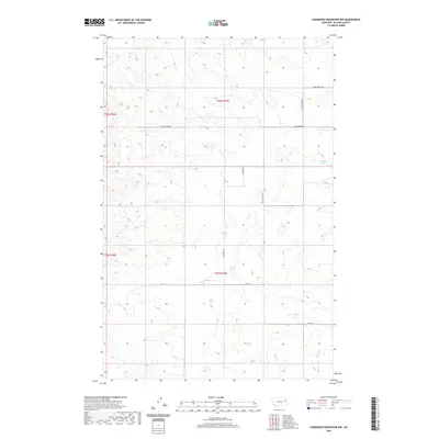
2020 Map of Hudiburgh Reservoir NW
USGS Topo · Published 2020About this map
Cow Cr and Duck Cr wind through this part of McCone County, defining a landscape shaped by intermittent water and rural infrastructure. The terrain is marked by a network of ranch and resource roads, including W Cow Creek Rd and Stoney Rd, which provide access to this isolated portion of the Missouri River basin. A notable landmark for water in this arid environment is Blackjack Spring, located in the eastern portion of the quadrangle. The presence of the Oil Field Svc Rd suggests the intersection of traditional cattle ranching with modern energy extraction, a common pattern in 21st-century Montana. This 2020 survey details the precise township and range boundaries, such as the junction of t23n r47e and t22n r47e, illustrating the continued importance of the Public Land Survey System in organizing the western plains.
Find a feature on this map
13 named features on this map. Tap any name to fly to it.
Don’t see what you’re looking for? This feature index may not catch every label — zoom into the map to look around manually.
Map Details
Editions of this 2020 Hudiburgh Reservoir NW Map
This is the sole edition of this map. No revisions or reprints were ever made.
Other maps of this area

1954 · Glendive
USGS Topo · 1:250,000

1957 · Glendive
USGS Topo · 1:250,000

1958 · Glendive
USGS Topo · 1:250,000

1983 · Haynie Reservoir
USGS Topo · 1:24,000

1983 · Hudiburgh Reservoir
USGS Topo · 1:24,000

1983 · Pedigo Coulee
USGS Topo · 1:24,000

1983 · Dailey Spring
USGS Topo · 1:24,000

1983 · North Fork Horse Creek
USGS Topo · 1:24,000

1983 · Hudiburgh Reservoir NW
USGS Topo · 1:24,000
1983 · Sadie Coulee
USGS Topo · 1:24,000