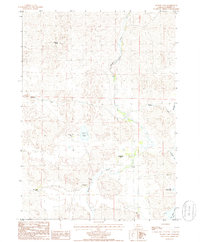
1985 Map of Hudson Lake
USGS Topo · Published 1986About this map
The Nebraska Sandhills landscape of Cherry County is defined by its ranching heritage and distinctive hydrology in this mid-1980s survey. Named cattle operations such as Bow and Arrow Ranch, Harris Ranch, and Sunny Slope Ranch are scattered across the terrain, reflecting the long-standing land-use patterns of the region. The map captures the essential water infrastructure required for this environment, including the Ainsworth Canal and a section of Gordon Creek that meanders through the central valley. Small, isolated landmarks like Rustlers Roost and a lonely Cem provide specific points of interest for local historians and genealogists. The southeastern corner is marked by a concentration of water bodies including Hudson Lake, Little Alkali Lake, and Big Alkali Lake, which serve as critical landmarks in a region dominated by rolling dunes and intermittent drainage such as Schlegel Cr.
Find a feature on this map
14 named features on this map. Tap any name to fly to it.
Don’t see what you’re looking for? This feature index may not catch every label — zoom into the map to look around manually.
Map Details
Editions of this 1985 Hudson Lake Map
This is the sole edition of this map. No revisions or reprints were ever made.
Other maps of this area

1950 · Simeon
USGS Topo · 1:62,500

1950 · Kennedy
USGS Topo · 1:62,500

1950 · Kilgore
USGS Topo · 1:62,500

1950 · Valentine
USGS Topo · 1:62,500

1957 · Valentine
USGS Topo · 1:250,000

1959 · Valentine
USGS Topo · 1:250,000

1983 · Valentine SW
USGS Topo · 1:24,000

1983 · Valentine South
USGS Topo · 1:24,000
1985 · Kilgore SE
USGS Topo · 1:24,000

1985 · Valentine
USGS Topo · 1:100,000