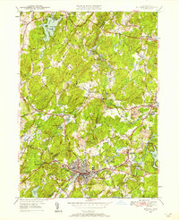
1950 Map of Hudson
USGS Topo · Published 1958About this map
The Assabet River winds through this central Massachusetts landscape, defining the industrial and social development of Hudson and Stow at mid-century. The river's path is closely followed by the Boston and Maine Railroad, which includes the Gleasondale Sta, a critical point for the small textile and mill settlements like Gleasondale. Education and community life are anchored by landmarks such as the Bromfield Academy and the Emerson Sch, while numerous burying grounds like St Michaels Cem and the Old Quaker Cem offer significant data for family historians. The terrain is marked by prominent drumlins and hills, including Gospel Hill and Rattlesnake Hill, which separate the agricultural fields of Bolton from the growing residential and commercial centers. Local recreation is evident at the Stow Country Club and Bare Hill Pond, illustrating the post-war shift toward leisure and suburban expansion in Middlesex and Worcester counties.
Find a feature on this map
69 named features on this map. Tap any name to fly to it.
Don’t see what you’re looking for? This feature index may not catch every label — zoom into the map to look around manually.
Map Details
Editions of this 1950 Hudson Map
Other maps of this area

1886 · Lowell
USGS Topo · 1:62,500

1886 · Framingham
USGS Topo · 1:62,500

1887 · Marlboro
USGS Topo · 1:62,500

1889 · Marlboro
USGS Topo · 1:62,500

1889 · Framingham
USGS Topo · 1:62,500

1893 · Lowell
USGS Topo · 1:62,500

1893 · Groton
USGS Topo · 1:62,500

1894 · Framingham
USGS Topo · 1:62,500

1896 · Marlboro
USGS Topo · 1:62,500

1898 · Marlboro
USGS Topo · 1:62,500