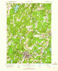
1950 Map of Hudson
USGS Topo · Published 1960About this map
The town of Hudson and the winding Assabet River anchor this 1950 revision of the landscape west of Boston. The map reveals a transition between concentrated industrial centers and the surrounding agricultural townships of Bolton and Stow. The Boston and Maine Railroad serves as a primary corridor through the area, linking the mill village of Gleasondale and its Gleasondale Sta to the larger population centers.
Find a feature on this map
82 named features on this map. Tap any name to fly to it.
Don’t see what you’re looking for? This feature index may not catch every label — zoom into the map to look around manually.
Map Details
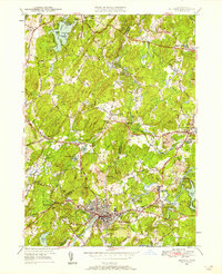
Editions of this 1950 Hudson Map

Other maps of this area

1886 · Lowell
USGS Topo · 1:62,500

1886 · Framingham
USGS Topo · 1:62,500

1887 · Marlboro
USGS Topo · 1:62,500

1889 · Marlboro
USGS Topo · 1:62,500

1889 · Framingham
USGS Topo · 1:62,500

1893 · Lowell
USGS Topo · 1:62,500

1893 · Groton
USGS Topo · 1:62,500

1894 · Framingham
USGS Topo · 1:62,500

1896 · Marlboro
USGS Topo · 1:62,500

1898 · Marlboro
USGS Topo · 1:62,500