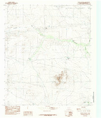
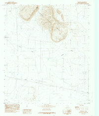
1984 Map of Hueco Station
USGS Topo · Published 1985About this map
Hueco Station serves as the focal point of this arid Hudspeth County landscape, characterized by essential water management infrastructure and remote desert terrain. In an area where water is the primary driver of survival and ranching, the map documents a series of critical man-made reservoirs including Holly Tank, Cascajo Tank, Six Tank, and the curiously named Pretty Soon Tank. These features are tied to the natural drainage of Antelope Draw and Antelope Gulch, which cut through the dry basins surrounding the prominent Antelope Hills. The infrastructure of the early 1980s is reflected in the presence of a Pumping Station and a Radio Tower, while industrial activity is noted at a local Gravel Pit. This provisional survey preserves the precise locations of these landmarks before shifting desert conditions or changing land use altered the local geography.
Find a feature on this map
11 named features on this map. Tap any name to fly to it.
Don’t see what you’re looking for? This feature index may not catch every label — zoom into the map to look around manually.
Map Details
Editions of this 1984 Hueco Station Map
This is the sole edition of this map. No revisions or reprints were ever made.
Other maps of this area

1951 · Dell City
USGS Topo · 1:62,500

1951 · Red Hills
USGS Topo · 1:62,500

1954 · Van Horn
USGS Topo · 1:250,000

1955 · Cerro Diablo
USGS Topo · 1:62,500

1955 · Black Mountains
USGS Topo · 1:62,500

1958 · Van Horn
USGS Topo · 1:250,000
1984 · Baylor Draw
USGS Topo · 1:24,000
1984 · Mickey Draw West
USGS Topo · 1:24,000
1984 · Black Mountains NW
USGS Topo · 1:24,000
1984 · Cornudas
USGS Topo · 1:24,000