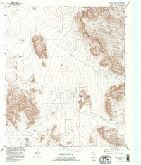
1995 Map of Hueco Tanks
USGS Topo · Published 1995About this map
Hueco Tanks State Historical Park centers this 1995 survey, preserving a vital natural oasis within the arid landscape of the Hueco Mountains. The area is characterized by these unique rock depressions or Hueco Tanks that collect rainwater, a feature that has drawn travelers to this desert corridor for centuries. To the west, the expansive Fort Bliss Military Reservation dominates the basin, marked by numerous named catchments like Kerby Tank and Mesquite Tank that reflect the essential role of water management in this high-desert environment. The eastern edge is defined by the steep Rimrock and the winding reaches of Hackberry Canyon. A network of 4WD tracks and utility corridors, including multiple Pipelines, underscores the modern infrastructure overlaying a terrain defined by ancient geological formations and isolated landmarks like the local Gun Club.
Find a feature on this map
24 named features on this map. Tap any name to fly to it.
Don’t see what you’re looking for? This feature index may not catch every label — zoom into the map to look around manually.
Map Details
Editions of this 1995 Hueco Tanks Map
This is the sole edition of this map. No revisions or reprints were ever made.
Other maps of this area

1896 · El Paso
USGS Topo · 1:125,000

1903 · Cerro Alto
USGS Topo · 1:125,000

1908 · El Paso
USGS Topo · 1:125,000

1939 · Heuco Tanks
USGS Topo · 1:62,500

1940 · Heuco Tanks
USGS Topo · 1:62,500

1940 · Bassett Lake
USGS Topo · 1:62,500

1941 · Heuco Mountains
USGS Topo · 1:62,500

1941 · Desert
USGS Topo · 1:62,500

1943 · Desert
USGS Topo · 1:62,500

1943 · Heuco Mountains
USGS Topo · 1:62,500
Featured Places
- Hueco Mountain Estates Number 4 Colonia, TX
- Hueco Mountain Estates Number 1 Colonia, TX
- Hueco Mountain Estates Number 3 Colonia, TX
- Hueco Mountain Estates Number 7 Colonia, TX
- Hueco Mountain Estates Number 5 Colonia, TX