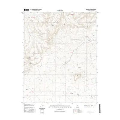
2017 Map of Huerfanito Peak
USGS Topo · Published 2017About this map
Huerfanito Peak dominates this San Juan County landscape, serving as a prominent landmark amidst a complex network of eroded drainages and elevated plateaus. The 2017 survey reveals a terrain defined by deep incisions like Muñoz Canyon and Armenta Canyon, which carve through the high ground of Harris Mesa. A rare water source, Armenta Canyon Spring, is located in the northwestern portion of the quadrangle, illustrating the critical points of hydrology in an otherwise arid environment. The map details a sparse infrastructure of rural roads, including RD 7225 and Co RD 7175, which navigate the various canyon floors and ridges. These routes suggest a landscape primarily utilized for grazing or resource access, connecting remote landmarks like Angel Peak and Reed Canyon across the township and range grid.
Find a feature on this map
18 named features on this map. Tap any name to fly to it.
Don’t see what you’re looking for? This feature index may not catch every label — zoom into the map to look around manually.
Map Details
Editions of this 2017 Huerfanito Peak Map
This is the sole edition of this map. No revisions or reprints were ever made.
Other maps of this area

1889 · Largo
USGS Topo · 1:250,000

1895 · Largo
USGS Topo · 1:250,000

1954 · Aztec
USGS Topo · 1:250,000

1958 · Aztec
USGS Topo · 1:250,000

1959 · Gould Pass
USGS Topo · 1:62,500

1959 · Nageezi
USGS Topo · 1:62,500

1960 · Bloomfield
USGS Topo · 1:62,500

1962 · Aztec
USGS Topo · 1:250,000

1965 · Aztec
USGS Topo · 1:250,000
1966 · Huerfano Trading Post NW
USGS Topo · 1:24,000