
1959 Map of Nageezi
USGS Topo · Published 1962About this map
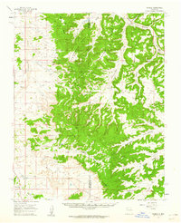
Nageezi and the surrounding high desert mesas define this 1959 survey of the San Juan Basin. The landscape is dominated by complex geological formations like Thompson Mesa, Mesa Smouse, and Escrito Mesa, separated by the deep incisions of Largo Canyon and Blanco Wash. This era shows a territory primarily utilized for resource extraction, evidenced by the extensive Gas Field and numerous labels for Oil Wells and Gas Wells scattered across the plateaus. Small-scale water management is visible at Crow Lake, Cricket Dam, and LaGotta Dam, highlighting the critical importance of water in this arid region. The sparse human presence is centered on local landmarks such as Dufers Point and Truby Ranch, while the county line between San Juan Co and Rio Arriba Co bisects the rugged terrain.
Find a feature on this map
26 named features on this map. Tap any name to fly to it.
Don’t see what you’re looking for? This feature index may not catch every label — zoom into the map to look around manually.
Map Details
Editions of this 1959 Nageezi Map
2 editions found
Other maps of this area

1889 · Largo
USGS Topo · 1:250,000

1895 · Largo
USGS Topo · 1:250,000

1954 · Aztec
USGS Topo · 1:250,000

1958 · Aztec
USGS Topo · 1:250,000

1959 · Gould Pass
USGS Topo · 1:62,500

1960 · Bloomfield
USGS Topo · 1:62,500

1962 · Aztec
USGS Topo · 1:250,000

1963 · Tayfoya Canyon
USGS Topo · 1:24,000

1963 · Gonzales Mesa
USGS Topo · 1:24,000
1963 · Santos Peak
USGS Topo · 1:24,000