
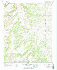
1963 Map of Tayfoya Canyon
USGS Topo · Published 1965About this map
The high desert landscape of Rio Arriba County is defined here by the intricate drainage systems of Largo Canyon and its many tributaries, including Tayfoya Canyon and Escrito Canyon. During the early 1960s, this region was a hub of energy development within the San Juan Basin gas field, evidenced by the dense network of gas wells, oil wells, and pipelines that crisscross the terrain. The western edge of the Jicarilla Apache Indian Reservation occupies the eastern portion of the map, where the Lindrith Pumping Station serves as a critical infrastructure point. Isolated ranching outposts like Old Rock Ranch, Mastico Ranch, and Otero Ranch provide glimpses into the rural settlement patterns of the era, while a remote landing strip and a series of unimproved roads highlight the logistical challenges of navigating this canyon-cut territory.
Find a feature on this map
34 named features on this map. Tap any name to fly to it.
Don’t see what you’re looking for? This feature index may not catch every label — zoom into the map to look around manually.
Map Details
Editions of this 1963 Tayfoya Canyon Map
2 editions found
Other maps of this area

1889 · Largo
USGS Topo · 1:250,000

1895 · Largo
USGS Topo · 1:250,000

1954 · Aztec
USGS Topo · 1:250,000

1958 · Aztec
USGS Topo · 1:250,000

1959 · Nageezi
USGS Topo · 1:62,500

1962 · Aztec
USGS Topo · 1:250,000

1963 · Lapis Point
USGS Topo · 1:24,000

1963 · Gonzales Mesa
USGS Topo · 1:24,000

1963 · Otero Store
USGS Topo · 1:24,000

1965 · Aztec
USGS Topo · 1:250,000