
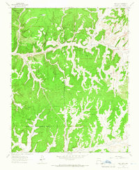
1963 Map of Lapis Point
USGS Topo · Published 1965About this map
Jicarilla Apache Indian Reservation lands dominate this high-desert plateau in Rio Arriba County, defined by a complex network of canyons and flat-topped mesas. The early 1960s landscape shows an active energy corridor within the San Juan Basin gas field, where numerous Gas Wells, Drill Holes, and Oil Wells are connected by pipelines and unimproved dirt tracks. This industrial overlay contrasts with the traditional terrain, which includes Eagles Nest and the prominent Lapis Point overlooking Lapis Valley. Drainage patterns are dictated by Tapicito Creek and Las Norias Canyon, which cut through the massive Wild Horse Mesa. The survey captures a moment of transition where traditional land boundaries meet mid-century resource extraction, providing a clear record of the access roads and infrastructure supporting the region's energy development.
Find a feature on this map
14 named features on this map. Tap any name to fly to it.
Don’t see what you’re looking for? This feature index may not catch every label — zoom into the map to look around manually.
Map Details
Editions of this 1963 Lapis Point Map
This is the sole edition of this map. No revisions or reprints were ever made.
Other maps of this area

1889 · Largo
USGS Topo · 1:250,000

1895 · Largo
USGS Topo · 1:250,000

1954 · Aztec
USGS Topo · 1:250,000

1958 · Aztec
USGS Topo · 1:250,000

1962 · Aztec
USGS Topo · 1:250,000

1963 · Schmitz Ranch
USGS Topo · 1:24,000

1963 · Tayfoya Canyon
USGS Topo · 1:24,000

1963 · Gonzales Mesa
USGS Topo · 1:24,000

1963 · Otero Store
USGS Topo · 1:24,000
1963 · Pine Lake
USGS Topo · 1:24,000