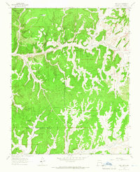
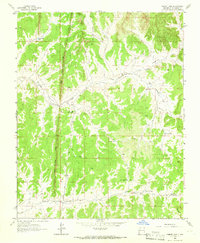
1963 Map of Pine Lake
USGS Topo · Published 1966About this map
The Jicarilla Apache Indian Reservation Boundary cuts across this high-desert landscape, where the southern reaches of the Carson National Forest meet a complex network of mesas and deep drainage systems. Natural water sources are critical features of this terrain, marked by remote landmarks such as Pine Lake, Lost Lake, and Coyote Lake, alongside numerous named springs including Chosh Spring and Bee Spring. The map reveals the early industrial footprint of the mid-20th century through several Gas Wells and a prominent pipeline that traverses the canyons. Significant geographic formations like Vigas Mesa and Chosa Mesa rise above winding waterways such as Arroyo Compañero and Tapicito Creek, illustrating the intersection of traditional tribal lands with modern energy extraction during the early 1960s.
Find a feature on this map
32 named features on this map. Tap any name to fly to it.
Don’t see what you’re looking for? This feature index may not catch every label — zoom into the map to look around manually.
Map Details
Editions of this 1963 Pine Lake Map
3 editions found
Other maps of this area

1889 · Largo
USGS Topo · 1:250,000

1895 · Largo
USGS Topo · 1:250,000

1954 · Aztec
USGS Topo · 1:250,000

1958 · Aztec
USGS Topo · 1:250,000

1962 · Aztec
USGS Topo · 1:250,000

1963 · Lapis Point
USGS Topo · 1:24,000

1963 · Schmitz Ranch
USGS Topo · 1:24,000

1963 · Gobernador
USGS Topo · 1:24,000
1963 · Ojito
USGS Topo · 1:24,000
1963 · Cement Lake
USGS Topo · 1:24,000