
1963 Map of Otero Store
USGS Topo · Published 1965About this map
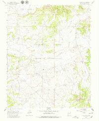
The Jicarilla Apache Indian Reservation defines this section of Rio Arriba County, where the high desert plateau is carved by an intricate network of drainages. The landscape is characterized by prominent landforms such as Wild Horse Mesa and the wide expanses of Lapis Valley and Navajo Valley. This 1963 field-checked survey captures the area during a period of active energy development, evidenced by the numerous Oil Wells scattered across the northern terrain and a prominent Pipeline cutting through the center. The eponymous Otero Store serves as a lone human landmark in the southern flats, situated near the headwaters of Cañada Larga. These labels reflect the region's ranching and resource extraction history, providing a precise look at the infrastructure that supported isolated outposts in the New Mexico backcountry.
Find a feature on this map
15 named features on this map. Tap any name to fly to it.
Don’t see what you’re looking for? This feature index may not catch every label — zoom into the map to look around manually.
Map Details
Editions of this 1963 Otero Store Map
2 editions found
Other maps of this area

1889 · Largo
USGS Topo · 1:250,000

1895 · Largo
USGS Topo · 1:250,000

1954 · Aztec
USGS Topo · 1:250,000

1958 · Aztec
USGS Topo · 1:250,000

1962 · Aztec
USGS Topo · 1:250,000

1963 · Lapis Point
USGS Topo · 1:24,000

1963 · Schmitz Ranch
USGS Topo · 1:24,000

1963 · Tayfoya Canyon
USGS Topo · 1:24,000

1963 · Gonzales Mesa
USGS Topo · 1:24,000
1963 · Billy Rice Canyon
USGS Topo · 1:24,000