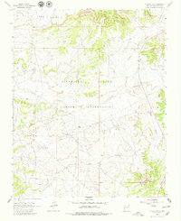
1963 Map of Otero Store
USGS Topo · Published 1979About this map
The Jicarilla Apache Indian Reservation encompasses this high desert landscape in Rio Arriba County, where the topography is defined by the broad Lapis Valley and the smaller Navajo Valley. The mid-20th-century economy of the region is visible through the scattered Oil Wells and a prominent Pipeline that cuts across the terrain. Central to the local geography are the landmarks of Otero and the Otero Store, which serve as primary reference points within the reservation's vast borders.
Find a feature on this map
15 named features on this map. Tap any name to fly to it.
Don’t see what you’re looking for? This feature index may not catch every label — zoom into the map to look around manually.
Map Details
Editions of this 1963 Otero Store Map
2 editions found
Other maps of this area

1889 · Largo
USGS Topo · 1:250,000

1895 · Largo
USGS Topo · 1:250,000

1954 · Aztec
USGS Topo · 1:250,000

1958 · Aztec
USGS Topo · 1:250,000

1962 · Aztec
USGS Topo · 1:250,000

1963 · Lapis Point
USGS Topo · 1:24,000

1963 · Schmitz Ranch
USGS Topo · 1:24,000

1963 · Tayfoya Canyon
USGS Topo · 1:24,000

1963 · Gonzales Mesa
USGS Topo · 1:24,000

1963 · Otero Store
USGS Topo · 1:24,000