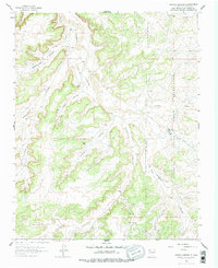
1963 Map of Tafoya Canyon
USGS Topo · Published 1978About this map
Canon Largo and its complex system of tributaries dominate this 1963 survey of the San Juan Basin gas field in Rio Arriba County. The landscape is defined by deep incisions such as Tafoya Canyon, Escrito Canyon, and Rockhouse Canyon, which reveal the area's geological character. This period represents a phase of industrial utility within the high desert, evidenced by the Lindrith Pumping Station and numerous gas wells connected by a network of pipelines and unimproved roads. To the east, the boundary of the Jicarilla Apache Indian Reservation runs through the rugged terrain, marking a clear jurisdictional line across Lapis Valley. Scattered ranching outposts, including Munoz Ranch and Otero Ranch, signify a sparse but persistent human presence amidst the broader energy infrastructure of the basin.
Find a feature on this map
16 named features on this map. Tap any name to fly to it.
Don’t see what you’re looking for? This feature index may not catch every label — zoom into the map to look around manually.
Map Details
Editions of this 1963 Tafoya Canyon Map
2 editions found
Other maps of this area

1889 · Largo
USGS Topo · 1:250,000

1895 · Largo
USGS Topo · 1:250,000

1954 · Aztec
USGS Topo · 1:250,000

1958 · Aztec
USGS Topo · 1:250,000

1959 · Nageezi
USGS Topo · 1:62,500

1962 · Aztec
USGS Topo · 1:250,000

1963 · Lapis Point
USGS Topo · 1:24,000

1963 · Tayfoya Canyon
USGS Topo · 1:24,000

1963 · Gonzales Mesa
USGS Topo · 1:24,000

1963 · Otero Store
USGS Topo · 1:24,000