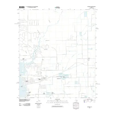
2010 Map of Huffman
USGS Topo · Published 2010About this map
Huffman serves as the central hub of this northeast Harris County landscape, situated at the junction of FM 1960 and FM 2100 Rd. The area is defined by the eastern shoreline of Lake Houston, where residential developments such as Lakewood Heights, Lakeside Manor, and Shorewood reach toward the water's edge. Beyond the suburban sprawl, the terrain is shaped by a complex network of waterways and drainage features, including Luce Bayou and a series of named gullies like Mexican Gully and Shook Gully that feed into the lake basin.
Find a feature on this map
70 named features on this map. Tap any name to fly to it.
Don’t see what you’re looking for? This feature index may not catch every label — zoom into the map to look around manually.
Map Details
Editions of this 2010 Huffman Map
This is the sole edition of this map. No revisions or reprints were ever made.
Other maps of this area

1916 · Crosby
USGS Topo · 1:24,000

1916 · Harmaston
USGS Topo · 1:24,000

1916 · Moonshine Hill
USGS Topo · 1:24,000

1916 · Huffman
USGS Topo · 1:24,000

1919 · Crosby
USGS Topo · 1:31,680

1920 · Harmaston
USGS Topo · 1:31,680

1920 · Moonshine Hill
USGS Topo · 1:31,680

1920 · Huffman
USGS Topo · 1:31,680

1943 · Liberty
USGS Topo · 1:125,000
1944 · Crosby
USGS Topo · 1:31,680