
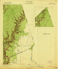
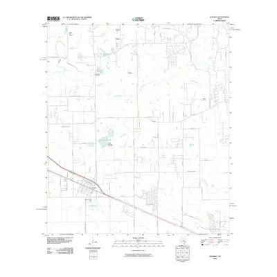
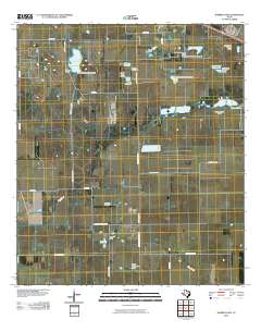
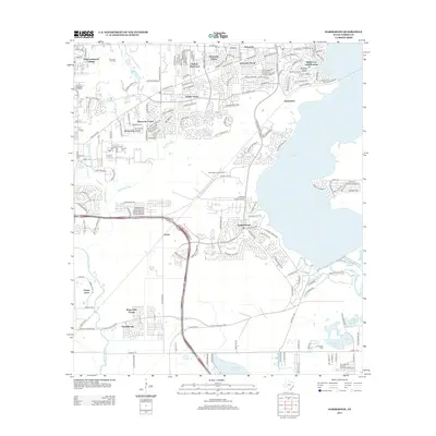
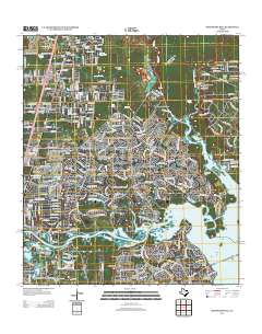
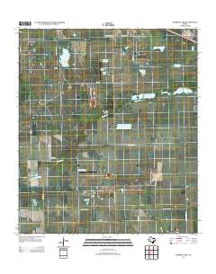
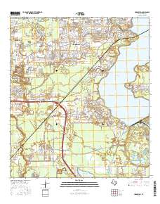
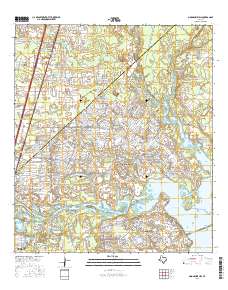
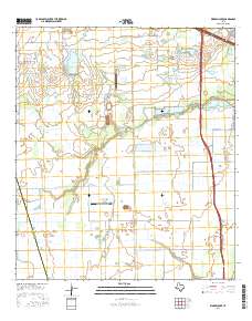
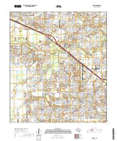
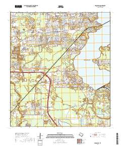
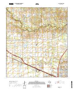
1920 Map of Huffman
USGS Topo · Published 1942About this map
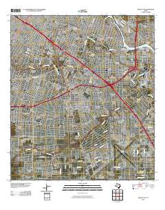
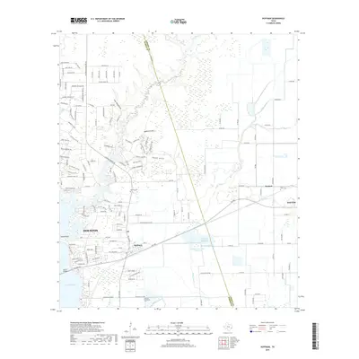
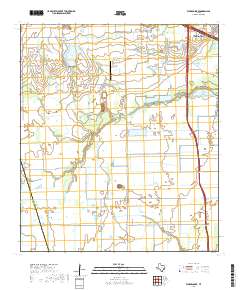
Huffman and the surrounding coastal prairie transition into the heavily dissected drainages of the East Fork San Jacinto River during this early 20th-century survey. The landscape is defined by its complex network of gullies, including Key Gully, John Young Gully, and Shock Gully, which carve deep contours into the terrain before feeding into Luce Bayou. This drainage pattern contrasts with the more level lands to the south where the Beaumont and Sour Lake Western rail line and Bradford are situated.
Find a feature on this map
21 named features on this map. Tap any name to fly to it.
Don’t see what you’re looking for? This feature index may not catch every label — zoom into the map to look around manually.
Map Details
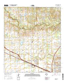
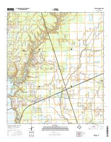
Editions of this 1920 Huffman Map
2 editions found
Historical Maps of Houston Through Time
145 maps found

1915 Addicks
Harris County, TX

1915 Alief
Harris County, TX

1915 Cypress
Harris County, TX

1915 Deepwater
Harris County, TX

1915 Hillendahl
Harris County, TX

1915 Houston Heights
Harris County, TX

1915 Park Place
Harris County, TX

1916 Burnett Bay
Harris County, TX

1916 Cedar Bayou
Harris County, TX

1916 Fauna
Harris County, TX

1916 Genoa
Harris County, TX

1916 Harmaston
Harris County, TX

1916 Hockley
Harris County, TX

1916 Huffman
Harris County, TX

1916 Louetta
Harris County, TX

1916 Moonshine Hill
Harris County, TX

1916 Rose Hill
Harris County, TX

1916 Satsuma
Harris County, TX

1916 Settegast
Harris County, TX

1916 Swanson
Harris County, TX

1918 Addicks
Harris County, TX

1918 Cypress
Harris County, TX

1918 Hillendahl
Harris County, TX

1919 Cedar Bayou
Harris County, TX

1919 Deepwater
Harris County, TX

1919 Swanson
Harris County, TX

1920 Burnett Bay
Harris County, TX

1920 Fauna
Harris County, TX

1920 Genoa
Harris County, TX

1920 Harmaston
Harris County, TX

1920 Hockley
Harris County, TX
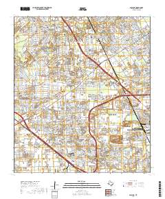
1920 Huffman
Harris County, TX

1920 Louetta
Harris County, TX

1920 Moonshine Hill
Harris County, TX

1920 Rose Hill
Harris County, TX

1920 Satsuma
Harris County, TX

1922 Houston Heights
Harris County, TX

1922 Park Place
Harris County, TX

1922 Settegast
Harris County, TX

1932 Fauna
Harris County, TX

1932 Genoa
Harris County, TX

1943 Cedar Bayou
Harris County, TX

1944 Burnett Bay
Harris County, TX

1944 Harmaston
Harris County, TX

1946 Houston Heights
Harris County, TX

1946 Settegast
Harris County, TX

1954 Harmaston
Harris County, TX

1955 Addicks
Harris County, TX

1955 Houston Heights
Harris County, TX

1955 Park Place
Harris County, TX

1955 Settegast
Harris County, TX

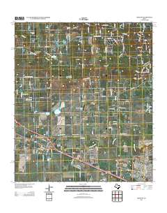
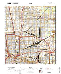
1960 Huffman
Harris County, TX

1961 Moonshine Hill
Harris County, TX

1962 Hockley
Harris County, TX

1962 Rose Hill
Harris County, TX

1967 Harmaston
Harris County, TX

1967 Houston Heights
Harris County, TX

1967 Park Place
Harris County, TX

1967 Settegast
Harris County, TX

1970 Addicks
Harris County, TX

1970 Alief
Harris County, TX

1970 Cypress
Harris County, TX

1970 Satsuma
Harris County, TX

1971 Warren Lake
Harris County, TX

1982 Alief
Harris County, TX

1982 Freindswood
Harris County, TX

1982 Harmaston
Harris County, TX

1982 Houston Heights
Harris County, TX

1982 Park Place
Harris County, TX

1982 Satsuma
Harris County, TX

1982 Settegast
Harris County, TX

1995 Addicks
Harris County, TX

1995 Alief
Harris County, TX

1995 Cypress
Harris County, TX

1995 Harmaston
Harris County, TX

1995 Houston Heights
Harris County, TX

1995 Moonshine Hill
Harris County, TX

1995 Park Place
Harris County, TX

1995 Satsuma
Harris County, TX

1995 Settegast
Harris County, TX
2010 Addicks
Harris County, TX

2010 Alief
Harris County, TX
2010 Cypress
Harris County, TX
2010 Harmaston
Harris County, TX
2010 Hockley
Harris County, TX
2010 Houston Heights
Harris County, TX
2010 Huffman
Harris County, TX
2010 Moonshine Hill
Harris County, TX
2010 Park Place
Harris County, TX
2010 Rose Hill
Harris County, TX
2010 Satsuma
Harris County, TX
2010 Settegast
Harris County, TX
2010 Warren Lake
Harris County, TX
2013 Addicks
Harris County, TX
2013 Alief
Harris County, TX
2013 Cypress
Harris County, TX
2013 Harmaston
Harris County, TX
2013 Hockley
Harris County, TX
2013 Houston Heights
Harris County, TX
2013 Huffman
Harris County, TX
2013 Moonshine Hill
Harris County, TX
2013 Park Place
Harris County, TX
2013 Rose Hill
Harris County, TX

2013 Satsuma
Harris County, TX
2013 Settegast
Harris County, TX
2013 Warren Lake
Harris County, TX
2016 Addicks
Harris County, TX
2016 Alief
Harris County, TX
2016 Cypress
Harris County, TX
2016 Harmaston
Harris County, TX
2016 Hockley
Harris County, TX
2016 Houston Heights
Harris County, TX
2016 Huffman
Harris County, TX
2016 Moonshine Hill
Harris County, TX
2016 Park Place
Harris County, TX
2016 Rose Hill
Harris County, TX
2016 Satsuma
Harris County, TX
2016 Settegast
Harris County, TX
2016 Warren Lake
Harris County, TX
2019 Addicks
Harris County, TX
2019 Alief
Harris County, TX
2019 Cypress
Harris County, TX
2019 Harmaston
Harris County, TX
2019 Hockley
Harris County, TX
2019 Houston Heights
Harris County, TX
2019 Huffman
Harris County, TX
2019 Moonshine Hill
Harris County, TX
2019 Park Place
Harris County, TX
2019 Rose Hill
Harris County, TX
2019 Satsuma
Harris County, TX
2019 Settegast
Harris County, TX
2019 Warren Lake
Harris County, TX

2022 Addicks
Harris County, TX

2022 Alief
Harris County, TX

2022 Cypress
Harris County, TX

2022 Harmaston
Harris County, TX

2022 Hockley
Harris County, TX

2022 Houston Heights
Harris County, TX

2022 Huffman
Harris County, TX

2022 Moonshine Hill
Harris County, TX

2022 Park Place
Harris County, TX

2022 Rose Hill
Harris County, TX

2022 Satsuma
Harris County, TX

2022 Settegast
Harris County, TX

2022 Warren Lake
Harris County, TX