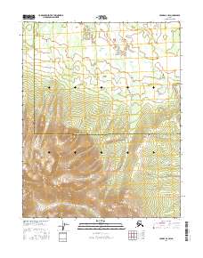
2016 Map of Hughes B-6 SW
USGS Topo · Published 2016About this map
Zane Hills dominates the southern half of this landscape, rising steeply from the drainage basins of the interior. The terrain is defined by the high prominence of Black Peak, which serves as a central landmark amidst the complex contouring of the hills. To the north, the elevation drops into a series of wetlands and stream networks, where water flows through Comeback Cr and Aloha Cr. This area sits at the intersection of the Yukon-Koyukuk Census Area and the Northwest Arctic Borough, capturing a remote boundary where topography dictates the flow of local hydrology rather than human development.
Find a feature on this map
12 named features on this map. Tap any name to fly to it.
Don’t see what you’re looking for? This feature index may not catch every label — zoom into the map to look around manually.
Map Details
Editions of this 2016 Hughes B-6 SW Map
This is the sole edition of this map. No revisions or reprints were ever made.
Other maps of this area

1951 · Shungnak
USGS Topo · 1:250,000

1951 · Hughes
USGS Topo · 1:250,000

1955 · Shungnak
USGS Topo · 1:250,000

1956 · Hughes
USGS Topo · 1:250,000

1964 · Shungnak
USGS Topo · 1:250,000

1964 · Hughes
USGS Topo · 1:250,000

1965 · Hughes
USGS Topo · 1:250,000
1985 · Shungnak B-1
USGS Topo · 1:63,360
1985 · Shungnak A-1
USGS Topo · 1:63,360
1986 · Hughes A-6
USGS Topo · 1:63,360