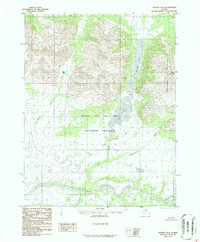
1986 Map of Hughes D-6
USGS Topo · Published 1986About this map
The Kobuk River flows through the southern portion of this landscape, a critical waterway in a region dominated by the Angayucham Mountains. This 1986 provisional edition, based on aerial photography from the early 1970s, documents a vast wilderness where water and elevation dictate the terrain. Much of the northern half is protected within the Gates of the Artic National Preserve, where significant water bodies like Narvak Lake and Selby Lake are situated beneath peaks like Fritts Mountain. The map also identifies Coal Pass, suggesting localized geological interest in an area otherwise defined by its complex drainage network, including the Killak River and the winding course of the Selby River. This survey provides a baseline of the Arctic environment before modern shifts, focusing entirely on the natural hydrology and topographical relief of the Brooks Range foothills.
Find a feature on this map
11 named features on this map. Tap any name to fly to it.
Don’t see what you’re looking for? This feature index may not catch every label — zoom into the map to look around manually.
Map Details
Editions of this 1986 Hughes D-6 Map
This is the sole edition of this map. No revisions or reprints were ever made.
Other maps of this area

1951 · Shungnak
USGS Topo · 1:250,000

1951 · Hughes
USGS Topo · 1:250,000

1951 · Survey Pass
USGS Topo · 1:250,000

1951 · Ambler River
USGS Topo · 1:250,000

1955 · Shungnak
USGS Topo · 1:250,000

1956 · Hughes
USGS Topo · 1:250,000

1956 · Survey Pass
USGS Topo · 1:250,000

1956 · Ambler River
USGS Topo · 1:250,000

1964 · Survey Pass
USGS Topo · 1:250,000

1964 · Shungnak
USGS Topo · 1:250,000