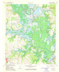
1971 Map of Hugo Dam
USGS Topo · Published 1973About this map
The Kiamichi River valley undergoes a massive transformation in this early 1970s survey, dominated by the Hugo Dam Under Construction near Sawyer. Blue hatching across the terrain indicates the vast areas of the river bottoms and tributaries like Long Creek and Salt Creek destined to be submerged by Hugo Lake. This transition from riverine woodland to a massive reservoir is captured at its midpoint, showing established communities and family landmarks before the waters rose. Genealogy researchers can find the Messer Cem and Dixon Chapel Cem, along with the Trinity Ch near Messer. The infrastructure of Hugo is visible in the southwest, including the Hospital, Nash Airport, and the St Louis-San Francisco railroad line which borders the southern edge of the new dam site.
Find a feature on this map
30 named features on this map. Tap any name to fly to it.
Don’t see what you’re looking for? This feature index may not catch every label — zoom into the map to look around manually.
Map Details
Editions of this 1971 Hugo Dam Map
This is the sole edition of this map. No revisions or reprints were ever made.
Other maps of this area

1901 · Antlers
USGS Topo · 1:125,000

1901 · Alikchi
USGS Topo · 1:125,000

1903 · Paris
USGS Topo · 1:125,000

1912 · Antlers
USGS Topo · 1:125,000

1925 · Antlers
USGS Topo · 1:125,000

1948 · Grant
USGS Topo · 1:62,500

1949 · Grant
USGS Topo · 1:62,500

1950 · Mcalester
USGS Topo · 1:250,000

1951 · Frogville
USGS Topo · 1:24,000

1951 · Shoals
USGS Topo · 1:24,000